Trail Walking Les Mées - Les Pénitents - circuit court - Les Mées - Photo

Les Pénitents - circuit court - Les Mées

 tracegps
tracegps

User

© OpenStreetMap contributors
Length
Length
5.8 km
Max alt
Max alt
589 m
Uphill gradient
Uphill gradient
278 m
Km-Effort
Km-Effort  
9.5 km
Min alt
Min alt
408 m
Downhill gradient
Downhill gradient
287 m
Boucle
Boucle
Yes
Creation date :
2014-12-10 00:00:00.0
Updated on :
2014-12-10 00:00:00.0

(2 Reviews)

Walking
Walking
2h00
Difficulty : Medium

Scan this QR Code to open this trail in the SityTrail application

FREE GPS app for hiking

Logo SityTrail SityTrail

IGN / Geographical institutes

Download SityTrail from the App Store Download SityTrail from Google Play

Logo SityTrail SityTrail World

The world is yours!

Download SityTrail from the App Store Download SityTrail from Google Play Download SityTrail on Huawei AppGallery

About

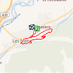
Trail Walking of 5.8 km to be discovered at Provence-Alpes-Côte d'Azur, Alpes-de-Haute-Provence, Les Mées. This trail is proposed by tracegps.

Description

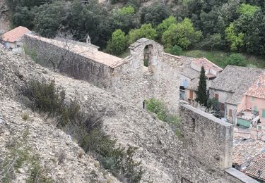
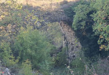
Cette rando doit se faire dans ce sens pour plus de sécurité (on monte face à la montagne au lieu de descendre face au vide comme proposé trop souvent) puis ravitaillement en eau à la Bonne Fontaine, passage devant un portail classé aux monuments historiques dans une rue atypique du village et retour au départ.

Elevation profile

Photos

Points of interest

Point of interest Les Mées - Camping - Photo
tracegps
LES MÉES 
Point of interest Les Mées - Debut de la montée - Photo
tracegps
Point of interest Les Mées - En haut des Pénitents - Photo
tracegps
Point of interest Les Mées - Fini - Photo
tracegps
LES MÉES 

Positioning

Country:
France
Region :
Provence-Alpes-Côte d'Azur
Department/Province :
Alpes-de-Haute-Provence
Municipality :
Les Mées
Location:
Unknown
Start:(UTM)
739082 ; 4879745 (31T) N.

Comments

Please log in to post a review or rate the element


Trails nearby

Trail Walking Les Mées - Les Mées - Malijai - Les Mées - Photo
Walking
tracegps

Walking

Medium
(1)
Les Mées, Provence-Alpes-Côte d'Azur, Alpes-de-Haute-Provence, France
12.1 km | 18.1 km-effort
4h 30min
Yes
Trail Walking Les Mées - Les Pénitents - circuit long - Les Mées - Photo
Walking
tracegps

Walking

Medium
(1)
Les Mées, Provence-Alpes-Côte d'Azur, Alpes-de-Haute-Provence, France
14.3 km | 21 km-effort
4h 0min
Yes
Trail Walking Les Mées - 2023-04-14 Les Apollinaires- Haute montagne - Les Pénitents  - Photo
Walking
GUIDE
Kargil

Walking

Medium
Les Mées, Provence-Alpes-Côte d'Azur, Alpes-de-Haute-Provence, France
17.5 km | 26 km-effort
5h 49min
Yes
Trail Running Peyruis - trail 29 07 2013 - Photo
Running
zapi

Running

Medium
(1)
Peyruis, Provence-Alpes-Côte d'Azur, Alpes-de-Haute-Provence, France
13.5 km | 20 km-effort
1h 27min
Yes
Trail Walking Les Mées - les mees . oratoire Saint Antoine.  - Photo
Walking
Roger

Walking

Easy
Les Mées, Provence-Alpes-Côte d'Azur, Alpes-de-Haute-Provence, France
8 km | 10 km-effort
2h 32min
Yes
Trail Walking Les Mées - les mees . Apollinaire par le sentier des oliviers  - Photo
Walking
Roger

Walking

Medium
Les Mées, Provence-Alpes-Côte d'Azur, Alpes-de-Haute-Provence, France
10.3 km | 14.7 km-effort
3h 10min
Yes
Trail Walking Montfort - 2023-11-07 Tour de la Louviere et Chapelle Saint Donat - Photo
Walking
GUIDE
Kargil

Walking

Medium
Montfort, Provence-Alpes-Côte d'Azur, Alpes-de-Haute-Provence, France
12.9 km | 16.7 km-effort
3h 47min
Yes
Trail Walking Puimichel - puimichel.  les vilards.  - Photo
Walking
Roger

Walking

Medium
Puimichel, Provence-Alpes-Côte d'Azur, Alpes-de-Haute-Provence, France
11.1 km | 15 km-effort
3h 28min
Yes
Trail On foot Les Mées - Le chemin de la Colle - Photo
On foot
PRO

On foot

Easy
Les Mées, Provence-Alpes-Côte d'Azur, Alpes-de-Haute-Provence, France
6.1 km | 7.1 km-effort
1h 36min
No


Close
My subscriptions